The post on this site of 12/27/07 took a look at the ownership of the various lots in Block 9 of the original Town of Bradley. That is the block on which is located the Bradley City Hall, Fire Department and R. B.’s Car Wash & Mini-Storage.
We will now take a similar look at Block 10 of the original Town of Bradley. This is the block which is on the left (south) as one crosses the railroad tracks westbound on Fourth St./Highway 160. Bradley Ag Supply, Inc., is located in the northeast corner of this block, and Coker Hardware is located in the northwest corner. Just to the west of Bradley Ag Supply, Inc., is Kevin’s Kitchen, in the building which formerly housed Middlebrooks Grocery and, before that, J. M. Drake General Merchandise.
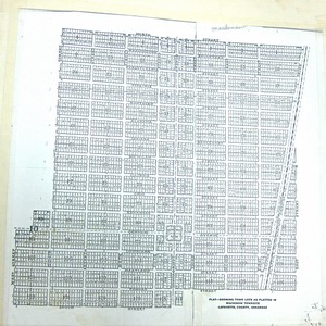
The following diagram illustrates the current (2008) assessments-ownership of the various lots in Block 10. Lots 1 through 6, which front Pullman St., are 50 ft. wide and 140 ft. deep. Lots 7 through 18, which front Pilot St. and the railroad right-of-way, are 25 ft. wide and 140 ft. deep.

6 Marvin McCalman, Jr. 7 (East) Bradley Ag Supply, Inc.
(West) Kevin J. Harris
8 (East Bradley Ag Supply, Inc.
(West) Kevin J. Harris
5 Marvin McCalman, Jr. 9 (East) Bradley Ag Supply, Inc.
(West) Kevin J. Harris
10 (East Bradley Ag Supply, Inc.
(West) Kevin J. Harris
4 Marvin McCalman, Jr. 11 (East) Bradley Ag Supply, Inc.
(West) Kevin J. Harris
12 Dorothy H. Burns
3 Larry Denham 13 Dorothy H. Burns
14 (East) Dorothy H. Burns
(West) Andrew & Rosie Couch
2 Melinda Warren 15 (East) Dorothy H. Burns
(West) Andrew & Rosie Couch
16 Melinda Warren
1 Melinda Warren 17 Melinda Warren
18 Melinda Warren
Block 10, being slightly further away from the railroad depot than Block 9, was not quite as important in Bradley’s commercial development as Block 9. Lots 7 through 18 in both blocks were similarly developed, and both blocks shared similar development along the land which abutted Fourth St./Highway 160. However, the southwest corner of Block 10, i.e., Lots 1, 2, and 3, furthest from the depot, was not as consistently the site of businesses over the years as were Lots 4, 5, and 6 of Block 9, correspondingly furthest from the depot in that block.
– – – – –
Below are the assessments for Block 10 in 1906, which was the first year that land in Bradley was assessed by lots and blocks, instead of by metes and bounds, after the Town of Bradley was incorporated in 1905.

6 Reubin Meredith 7 Rob’t Morgan
8 D. O. Simmons
5 J. P. Garner 9 Haley Smith
10 Brock & Smith
4 Southwestern Improvement Assn. 11 Brock & Smith
12 Masonic Lodge
3 Southwestern Improvement Assn. 13 Masonic Lodge
14 Haley Smith
2 Southwestern Improvement Assn. 15 W. J. Chandler
16 B. T. Philyaw
1 Southwestern Improvement Assn. 17 B. T. Philyaw
18 B. T. Philyaw
J. P. Garner (Lot 5) was the person who was listed first as one of the petitioners to the Lafayette County Court for incorporation of the Town of Bradley in 1905.
The Southwestern Improvement Association was an arm of the St. Louis Southwestern Railway Co., created for the purpose of developing the railroad’s right-of-way and land adjacent to it. Much of what we know as Bradley today was once owned by the Southwestern Improvement Association.
– – – – –
The 1910 assessments for Block 10 are shown below:
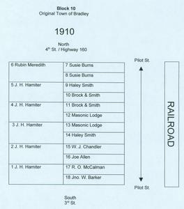
6 Rubin Meredith 7 Susie Burns
8 Susie Burns
5 J. H. Hamiter 9 Haley Smith
10 Brock & Smith
4 J. H. Hamiter 11 Brock & Smith
12 Masonic Lodge
3 J. H. Hamiter 13 Masonic Lodge
14 Haley Smith
2 J. H. Hamiter 15 W. J. Chandler
16 Joe Allen
1 J. H. Hamiter 17 R. O. McCalman
18 Jno. W. Barker
– – – – –
Shown below are the assessments in Block 10 for 1920:

6 Ruben Meredith 7 P. M. Allen
8 Warren Drug Store
5 Mrs. Lula Smith 9 J. J. Allen
10 G. B. LeCroy
4 Mrs. Lula Smith 11 Joe Allen, Sr.
12 Masonic Lodge
3 Mrs. Lula Smith 13 Masonic Lodge
14 S. S. Simmons
2 Mrs. Lula Smith 15 P. M. Allen
16 Joe Allen, Sr.
1 Mrs. Lula Smith 17 C. H. Barham
18 J. W. Barker
– – – – –
Shown below are the assessments in Block 10 for 1930. They are notable for the first appearance on the by-decade list of the person to whom the southeast corner of Block 10, i.e., Lot 18, was assessed.
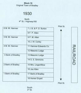
6 M. M. Hamner 7 J. B. & P. D. Burton
8 F. P. Allen
5 M. M. Hamner 9 P. M. Allen
10 J. W. Corley
4 M. M. Hamner 11 Hamner-Edwards Co.
12 Masonic Lodge
3 Bank of Bradley 13 Masonic Lodge
14 S. S. Simmons
2 Bank of Bradley 15 Mrs. Lingenfillow [sp?]
16 Joe Allen
1 Bank of Bradley 17 Bank of Bradley
18 Homer Enyart
– – – – –
Shown below are the assessments in Block 10 for 1940:
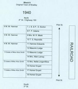
6 M. M. Hamner 7 J. B. & P. D. Burton
8 F. P. Adams
5 M. M. Hamner 9 Mrs. M. R. Meek
10 T. S. Reynolds
4 M. M. Hamner 11 Hamner-Edwards
12 Masonic Lodge
3 Estate of Miss Alice Smith 13 Masonic Lodge
14 Mrs. Allen Lemay
2 Estate of Miss Alice Smith 15 Mrs. Nellie Lingenfillow
16 Homer Enyart
1 Estate of Miss Alice Smith 17 Homer Enyart
18 Homer Enyart
The 10/15/07 post on this site shows the 1938 fire which engulfed the electric and ice plant on Lot 18, which Homer Enyart had built about 1925 or 1926. To the right of the fire in that photograph can be seen a small building and then a two-story building. According to Glynn McCalman’s Bradley Connections: “North of the ice plant was a two story boarding house/restaurant operated by Nellie Lingenfelter ( [born] c1860), a widow, and a native of Indiana.”
– – – – –
The 1950 assessments for Block 10 are shown below:
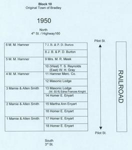
6 M. M. Hamner 7 J. B. & P. D. Burton
8 J. B. & P. D. Burton
5 M. M. Hamner 9 Mrs. M. R. Meek
10 (West) T. S. Reynolds
(East) W. H. Gray
4 M. M. Hamner 11 Hamner Merc. Co.
12 Masonic Lodge
3 Mamie & Allen Smith 13 Masonic Lodge
(W.50 ft) Edna Frances Knight
14 Homer E. Enyart
2 Mamie & Allen Smith 15 Martha Ann Enyart
16 Homer E. Enyart
1 Mamie & Allen Smith 17 Homer E. Enyart
18 Homer E. Enyart
– – – – –
Shown below are the assessments in Block 10 for 1960.

6 M. M. Hamner 7 J. B. & P. D. Burton
8 J. B. & P. D. Burton
5 M. M. Hamner 9 Mrs. M. R. Meek
10 (West) T. H. Reynolds
(East) W. H. Gray
4 M. M. Hamner 11 Hamner Merc. Co.
12 Masonic Lodge
3 W. O. Weems 13 Masonic Lodge
(W. 50 ft) Valma C. Vaughan
14 Homer E. Enyart
2 W. O. Weems 15 Martha Ann Enyart
16 Homer E. Enyart
1 W. O. Weems 17 Homer E. Enyart
18 Homer E. Enyart