
The real property records in the various offices of the Lafayette County Courthouse are an historical resource that is often neglected. Those records, of course, go back to the very founding of both Bradley and Lafayette County itself.
What follows is the first of several posts, over a period of probably several months, that will show ownership of lots located in some of the various blocks which comprised the original plat of the Town of Bradley. Each post will begin with a rough diagram of the buildings and landmarks in each block as of 2007 or 2008. Next will follow a plat showing the persons or firms assessed for tax purposes (and, therefore, ownership) in 1906, the first year in which the land occupied by the original Town of Bradley was assessed for tax purposes by lots, instead of as pieces of sections (square miles). After that will follow a plat showing the assessments in the first year of each new decade from 1910 to 1960.
The original Town of Bradley was laid out with 300–ft. square blocks. All lots are 50 feet wide and 140 feet long, except those lots which front the railroad, which are the same length, but only 25 feet wide. So, in the diagrams of Block 9 below, lots 1 through 6 are 50 x 140, and lots 7 though 18 are 25 x 140, because they front the railroad. Streets in the original Town of Bradley are 60 feet wide, and alleys are 20 feet wide. The diagrams of Block 9 below purposely omit the alley from the middle of each block in order to provide a little more space to list the owners of each lot. I.e., lots 1 through 6 do not actually abut lots 7 through 18, because there is a 20–ft. wide alley in between which is purposely not shown in the diagram.
Block 9 is the first block one encounters on the right (north side) when crossing the railroad on Highway 160 (Fourth St.) westbound. The site of the railroad depot in each of the following diagrams was just to the left of the bottom of the rectangle marked “RAILROAD.”
2007
The approximate location of some of the buildings and landmarks in Block 9 as of today are shown in this diagram:

6 7 Vickie’s Beauty Shop
(old Lodge Hall)
8 Vickie’s Beauty Shop
(old Lodge Hall)
5 Bradley Fire Dept. 9
10
4 Bradley Fire Dept 11
12
3 Bradley City Hall 13
14
2 15 RB’s Car Wash & Mini-Storage
16 RB’s Car Wash * Mini-Storage
1 17 RB’s Car Wash & Mini-Storage
18 RB’s Car Wash & Mini-Storage
1906
The 1906 assessments for this block show who owned each lot at the time the City of Bradley was incorporated. Lots 9, 10, and 11 show the location of the Lee Bros.-Holland Hdwe. building, which was the subject of the October 8, 2007, post on this site. The lots fronting the railroad (7 through 18) were designed to be the commercial hub of Bradley and most, if not all, of those lots at this time were probably occupied by stores or other commercial entities or ventures of one type or another.

6 Rosetta Leonard 7 T. T. McGee
8 E. H. Randle
5 G. M. & R. R. Lee 9 G. M. & R. R. Lee
10 G. M. & R. R. Lee
4 G. M. & R. R. Lee 11 G. M. & R. R. Lee
12 G. W. Reynolds
3 Southwestern Improvement 13 Pierce Adams
Association 14 W. C. Bradley
2 S. G. Gray 15 L. W. Ham
16 E. H. Randle
1 S. G. Gray / 17 Hamiter Bros.
E. P. Thruston 18 Hamiter Bros.
1910
The 1910 assessments, only four years later, show few changes in the assessments.

6 Haley Smith 7 T. T. McGee
8 E. H. Randle
5 G. M. & R. R. Lee 9 G. M. & R. R. Lee
10 G. M. & R. R. Lee
4 G. M. & R. R. Lee 11 G. M. & R. R. Lee
12 G. W. Reynolds
3 State of Arkansas 13 Pierce Adams
14 J. B. & D. Bradley
2 S. G. Gray, Caroline Gray 15 L. W. Ham
16 E. H. Randle
1 S. G. Gray, Caroline Gray 17 H. A. McCants
18 H. A. McCants
1920
By 1920, the Bank of Bradley had appeared on the assessment list (Lot 16).
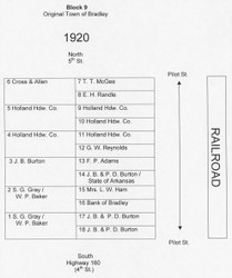
6 Cross & Allen 7 T. T. McGee
8 E. H. Randle
5 Hollland Hdw. Co. 9 Holland Hdw. Co.
10 Holland Hdw. Co.
4 Holland Hdw. Co. 11 Holland Hdw. Co.
12 G. W. Reynolds
3 J. B. Burton 13 F. P. Adams
14 J. B. & P. D. Burton /
State of Arkansas
2 S. G. Gray / 15 Mrs. L. W. Ham
W. P. Baker
16 Bank of Bradley
1 S. G. Gray / 17 J. B. & P. D. Burton
W. P. Baker
18 J. B. & P. D. Burton
1930
The 1930 assessments:
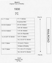
6 J. T. Cross 7 T. T. McGee
8 Lenona Allen
5 R. M. Holland 9 R. M. Holland
10 R. M. Holland
4 R. M. Holland 11 R. M. Holland
12 G. W. Reynolds
3 J. B. & P. D. Burton 13 F. P. Adams
14 J. B. & P. D. Burton
2 W. P. Baker 15 Cora E. Pearce
16 Bank of Bradley
1 W. P. Baker 17 J. B. & P. D. Burton
18 J. B. & P. D. Burton
1940
The 1940 assessments:

6 Frank Cochran 7 J. T. Cross
8 Marie Herring
5 R. M. Holland 9 R. M. Holland
10 R. M. Holland
4 R. M. Holland 11 R. M. Holland
12 O’Neal & Crockett
3 J. B. & P. D. Burton 13 R. B. Waller
14 J. B. & P. D. Burton
2 Mrs. Blanche Baker / 15 Mrs. Cora E. Pearce
M. M. Hamner
16 Bank of Bradley
1 Mrs. Blanche Baker/ 17 J. B. & P. D. Burton
M. M. Hamner
18 J. B. P. D. Burton
1950
By 1950, the Bank of Bradley had added another lot (15).

6 Frank Cochran 7 J. T. Cross
8 Marie Herring
5 J. B. Edwards 9 J. G. O’Neal Estate
10 J. G. O’Neal Estate
4 J. B. Edwards 11 J. G. O’Neal Estate
12 Mrs. W. M. McKissick /
Owen Jester
3 J. B. & P. D. Burton 13 Mrs. W. M. McKissick /
Owen Jester
14 J. B. & P. D. Burton
2 M. M. Hamner 15 Bank of Bradley
16 Bank of Bradley
1 M. M. Hamner 17 J. B. & P. D. Burton
18 J. B. & P. D. Burton
1960
By 1960, the Walnut Hill Lodge appears in the assessments.
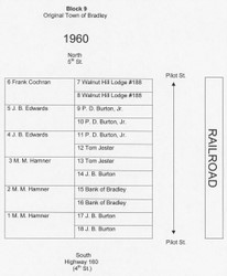
6 Frank Cochran 7 Walnut Hill Lodge #188
8 Walnut Hill Lodge #188
5 J. B. Edwards 9 P. D. Burton, Jr.
10 P. D. Burton, Jr.
4 J. B. Edwards 11 P. D. Burton, Jr.
12 Tom Jester
3 M. M. Hamner 13 Tom Jester
14 J. B. Burton
2 M. M. Hamner 15 Bank of Bradley
16 Bank of Bradley
1 M. M. Hamner 17 J. B. Burton
18 J. B. Burton
Assessments from other blocks from the original Town of Bradley will appear in future posts.
